When Seth came home from BYU this Spring, the Young Men's president invited him to go on the Teacher/Priest "High Adventure" trip. Last year they made rafts and floated down a river for three days. This year they rented mountain bikes and rode 100 miles on the White Rim trail in Canyon Lands National Park near Moab, Utah. Seth didn't mind me going, and since we had two support vehicles, I was able to take my DSLR camera and served as the group photographer. I also had my point and shoot in my backpack at all times for when I wasn't near the truck when a scenic moment appeared.
Moab is about a six-hour drive west from Denver. We left Wednesday morning, and arrived in Moab about 4pm. The bikes we rented were fairly high quality, and cost $33 per day plus $5 per day to rent, which turned out to be a great deal. We also rented bike racks. The drive from Moab to the beginning of the trail was about 45 minutes. We wanted to start later in the day so as to avoid the heat of the day. As it turned out we were blessed with cooler weather with day-time highs between 80 and 95 degrees.
Our original plan was to ride in a big loop, but the Green River is currently at flood stage and part of the trail and campsite is under water, so we rode in as far as we could go and then came back. There were some very steep and technical sections where we had to walk up or down, but for the most part the ascents and descents were rideable. On the first evening we rode 21 miles, the next day 35 miles and the day after that 40. The last day the boys rode just a couple of miles from our campsite at the edge of town to the bike store to finish out the 100 miles.
We had two four-wheel drive pickup trucks as support vehicles that carried our camping gear, field kitchen, tools for repairs, food, and 150 gallons of water in three big barrels. Our campsites had out-houses but no other amenties. The adults traded off driving the trucks.
The scenery was amazing, but it was lots of hard work. The trip might be more pleasant in the Spring or Fall when temperatures are cooler. As it was, we were basically the only group in the park while we were there, and the only group on bikes. It is a trip I think our family should do some day soon.
This is where we rented our bikes.

One of our two support vehicles loaded with gear and one of our three 50-gallon water barrels.

Another bike store down the street from where we rented our bikes had cool, filtered water where we filled out our drink bottles and camel-backs.

This picture is taken from where we parked two of our cars. It shows a place near the beginning of the trail where we start to descend into the canyon. It was a very steep trail that is over two miles long. Scary to ride down, since a loss of control means a very long fall.
I took some of these pictures from across the canyon with my telephoto lens.


This is another picture from the descent. You can see the road we will be following heading out into the distance. The trail eventually crosses from right to left of the mesa off in the distance. You can see a while line on the side of the mesa, that is the "white rim" and the trail is on that white part. Our camp the first night was on the other side of that mesa.

Looking back from the valley floor at the descent.

This was where we spent the first night. Notice the lack of amenties except for the kybo.
Seth and his riding buddies. The trail actually does go that close to the edge. That drop is at least 500 feet. Kind of scary.

There were a few puddles on the trail from little summer squalls that we had our first night. This is my bike, gloves, backpack and helmet.

Our campsite looking in the opposite direction. We are all packed up and almost ready to head out.

This is the best picture of the trip. We're about 3/4 of the way to our next camp site; about 30 miles in. This view was worth the ride in.


The boys refer to this as "the hill of death". Impossible for most mortals to ride up; harder to ride down. The trail is covered in very loose rock. One of our leaders tried riding down and went over the handle bars.

Another great telephoto shot. Seth didn't smile because he thought I was too far away. The next picture you can see where I was standing, and where
he was standing. This little bit of scenery was about 100 yards down a trail from our second camp.


One of our group photos, taken from the other side of rock. Actually a little scary to get out there.

Even scarier to get
here. It isn't connected to the closer column. You have to jump a narrow gap between them. The gap doesn't get more narrow as it goes down; it opens up into thin air. You can see the gap at the bottom of the screen and a little to the left. Like I said, a little scary...


Our campsite the second night.

After the boys finished dinner, they crashed long before it got dark. At night the temperatures dropped to the low 70's.

My bike get dirtier as the trip gets longer. Ice blue Gaterade at 3/4 strength in my 21oz drink bottle. I also carried 2 liters of fresh water in my camelback. By the third day all of our water was about 90 degrees, including our Gaterade.

Seth is ready for the third day of riding.

I was really disappointed that this picture didn't turn out as cool as I had hoped. Remember that scene in Indiana Jones and Last Crusade where he throws the sand to show the narrow rock path across the canyon? I am standing on Musselman Arch, and there is about 1000 feet of air under that five-foot thick rock I am standing on. Another scary walk.

A view of the Colorado River from the rim of the canyon.

We're about 4 miles from the end of the trail, and now we are mentally-preparing to go
up that very long, steep trail we came down at the beginning of the adventure. This kybo provided about the only shade available until our trucks showed up with the pop-up awnings.

Ummm, can I just say it was pretty hot out in the sun? This is what had happened to our cheese by the end of our lunch break.
After the long climb out we camped at at public campground on the Colorado River in the outskirts of Moab.

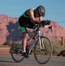
Seth and the rest of the boys are ready to ride the last couple of miles to turn in the bikes.

On the road heading into town.

This is in Glenwood Canyon about 45 minutes south of Vail. The Colorado River is at flood stage due to record snow pack in the Rockies and warm temperatures.